 Old Cumbria Gazetteer
 |
 |
|
| Lune Valley | ||
| Lonsdale | ||
| site name:- | Lune, River | |
| county:- | Cumbria | |
| county:- | Lancashire | |
| locality type:- | valley | |
| 10Km square:- | SD68 (etc) | |
| 1Km square:- | SD6080 | |
| 10Km square:- | SD45 | |
| 10Km square:- | SD46 | |
| 10Km square:- | SD56 | |
| 10Km square:- | SD57 | |
| 10Km square:- | SD67 | |
| 10Km square:- | SD68 | |
| 10Km square:- | SD69 | |
| 10Km square:- | NY60 | |
| 10Km square:- | NY70 | |
|
|
||
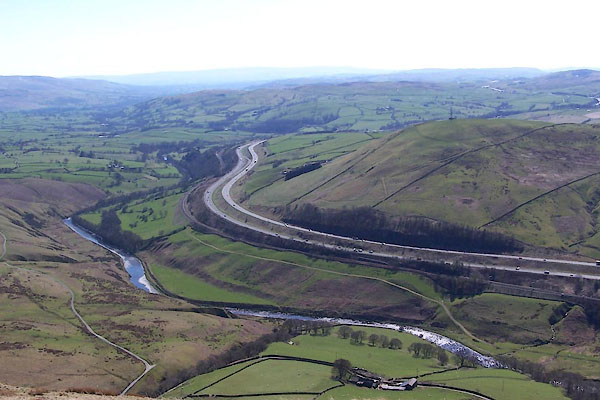 BWF45.jpg M6 motorway, Lancaster and Carlisle Railway, etc, (taken 5.4.2012) |
||
|
|
||
| evidence:- | old map:- Drayton 1612/1622 placename:- Launsdale |
|
| source data:- | Map, hand coloured engraving, Cumberlande and Westmorlande, by
Michael Drayton, probably engraved by William Hole, scale about
4 or 5 miles to 1 inch, published by John Mariott, John
Grismand, and Thomas Dewe, London, 1622.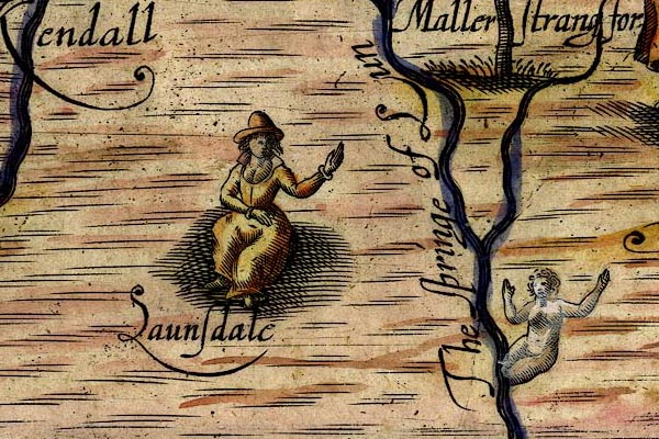 DRY524.jpg "Launsdale" Lady sitting. item:- JandMN : 168 Image © see bottom of page |
|
|
|
||
| evidence:- | descriptive text:- Simpson 1746 placename:- Vale upon the Lone |
|
| source data:- | Atlas, three volumes of maps and descriptive text published as
'The Agreeable Historian, or the Compleat English Traveller
...', by Samuel Simpson, 1746. goto source goto sourcePage 1024:- "..." "Kirkby Lonsdale, the chief Town of Lonsdale, i.e. a Vale upon the Lone, that Tract which gives Title of Viscount to the Family of Lowthers of Lowther Hall, in this County. ..." |
|
|
|
||
| evidence:- | descriptive text:- West 1778 (11th edn 1821) placename:- Vale of Lonsdale |
|
| source data:- | Guide book, A Guide to the Lakes, by Thomas West, published by
William Pennington, Kendal, Cumbria once Westmorland, and in
London, 1778 to 1821. goto source Page 25:- "'... [Mr. Gray's view from his station, Hornby Road] Here, Ingleborough, behind a variety of lesser mountains, makes the background of the prospect; on each hand of the middle distance rise two sloping hills, the left clothed with thick wood, the right with variegated rock" goto sourcePage 26:- "and herbage. Between them, is the richest of valleys, the Lune serpentizes for many a mile, and comes forth ample and clear thro' a well wooded and richly pastured foreground. Every feature which constitutes a perfect landscape of the extensive sort, is here not only boldly marked, but also in its best position.'" goto sourceTour to the Caves in the West Riding of Yorkshire, late 18th century Page 242:- "..." "From the top of the [Devil's] bridge the prospect down the river is delightful: ... We walked down by the side of the river about a mile, and as we proceeded were continually presented with new prospects; while the soft murmurs of the river afforded a variety of different notes. The vale of Lonsdale dilating by degrees, presented us in succession with the different seats and villages that adorn it: Whittington and Arkholme to the west; Tunstal, Melling, Hornby and its castle, to the south; and Leck to the east. The brown and blue mountains of Burnmore and Lyth-fell terminated the view, which we could have wished had extended still farther to the south. ..." goto sourcePage 253:- "[at Ingleton] ... The church-yard, in the middle of which stands a neat sacred edifice, commands a fine view of the vale of Lonsdale, almost as far as Lancaster. ..." |
|
|
|
||
| evidence:- | old text:- Camden 1789 placename:- Lonsdale |
|
| source data:- | Book, Britannia, or A Chorographical Description of the Flourishing Kingdoms of England,
Scotland, and Ireland, by William Camden, 1586, translated from the 1607 Latin edition
by Richard Gough, published London, 1789. goto source Page 147:- "..." "On the east the river Lone serves as a boundary, and gives its name to the adjacent tract of Lonsdale, q.d. the valley on the Lone, ..." |
|
|
|
||
| evidence:- | old text:- Camden 1789 (Gough Additions) placename:- Lune, River placename:- Lon, River |
|
| source data:- | Book, Britannia, or A Chorographical Description of the Flourishing Kingdoms of England,
Scotland, and Ireland, by William Camden, 1586, translated from the 1607 Latin edition
by Richard Gough, published London, 1789. goto source Page 150:- "..." "The rivers of this county [Westmorland] are but small, and only three that can properly be called rivers carry their name to the sea: ... The second is Lune or Lon, which has its source in Ravenstondale, and runs down the vale called from it Lonsdale, where it enters the county of Loncaster as it was antiently called, and a little below the town of Lancaster falls into the sea. ..." |
|
|
|
||
| evidence:- | descriptive text:- Baker 1802 |
|
| source data:- | Perspective road map with sections in Lancashire, Westmorland,
and Cumberland, by J Baker, London 1802. pp.25-26:- "... the rich luxuriant valley of the Lune, which Mr. Grey describes as possessing every feature which constitutes a perfect landscape. ..." |
|
|
|
||
| evidence:- | old print:- Wilkinson 1810 (plate 1) placename:- Vale of Lune |
|
| source data:- | Print, uncoloured soft ground etching, Vale of the Lune, Lonsdale, looking towards
Ingleborough Hill and Hornby Castle, Lancashire, by Joseph Wilkinson, engraved by
William Frederick Wells, published by R Ackermann, Repository of Arts, 101 Strand,
London, 1810.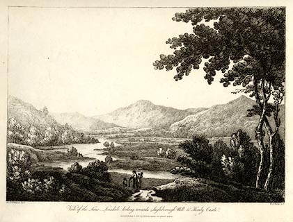 click to enlarge click to enlargeWKN101.jpg Plate 1 in Select Views in Cumberland, Westmoreland, and Lancashire. printed at bottom left, right, centre:- "Revd. J. Wilkinson delt. / W. F. Wells sct. / Vale of the Lune, Lonsdale, looking towards Ingleborough Hill &Hornby Castle. / Publish'd July 1. 1810. by R. Ackermann. 101. Strand. London." item:- Fell and Rock Climbing Club : MN4.1 Image © see bottom of page |
|
|
|
||
| evidence:- | old text:- Wordsworth 1810 |
|
| source data:- | Guide book, A Description of the Scenery of the Lakes, later A
Guide through the District of The Lakes, by William Wordsworth,
1810-35. goto source page iii "... Near Kirkby Lonsdale observe the view from the bridge over the Lune, and descend to the channel of the river, and by no means omit looking at the Vale of Lune from the Church-yard." |
|
|
|
||
| evidence:- | descriptive text:- Otley 1823 (8th edn 1849) |
|
| source data:- | Guide book, A Concise Description of the English Lakes, the
mountains in their vicinity, and the roads by which they may be
visited, with remarks on the mineralogy and geology of the
district, by Jonathan Otley, published by the author, Keswick,
Cumberland now Cumbria, by J Richardson, London, and by Arthur
Foster, Kirkby Lonsdale, Cumbria, 1823; published 1823-49,
latterly as the Descriptive Guide to the English Lakes. goto source Page 171:- "..." "THE VALLEY." "There are two routes from Lancaster to Kirkby Lonsdale: one by Halton, on the western, the other by Hornby on the eastern side of the river. The former is shorter by two miles; but being hilly and uninteresting, the latter route is generally preferred, as indeed it ought to be by the lovers of the picturesque. 'On approaching Caton, three miles from Lancaster,' says Whittaker, 'the character of the Vale of Lune, as one of the first of the northern vallies, is instantly and incontrovertibly esta-" goto sourcePage 172:- "[esta]blished. The noble windings of the river, the fruitful alluvial lands on its banks, the woody and cultivated ridge which bounds in on the north-west, the striking feature of Hornby Castle in front, and above all, the noble form of Ingleborough, certainly compose an assemblage not united in any rival scenery in the kingdom.' Before reaching Caton, on the high ground, a little on the right of the road, is the view up the valley rendered celebrated by the Poet Gray: 'Here Ingleborough, behind a variety of lesser mountains, makes the background of the prospect: on either hand of the middle distance, rises a sloping hill; the left clothed with thick woods, the right with variegated rock and herbage: between them, in the richest of valleys, the Lune serpentizes for many a mile, and comes forth, ample and clear, through a well wooded and richy pastured foreground. Every feature, which constitutes a perfect landscape of the extensive sort, is here not only boldly marked, but also in the best position.'" "Green, the faithful delineator of the picturesque lakes and mountains among which he so long lived, speaking as an artist on this subject, observes:" "'The vale of Lune, all the way from Lancaster to Hornby, (nine miles,) is singularly beautiful, and has its charms between the latter place and Kirkby Lonsdale, (eight miles more.) Hornby Castle, though of various dates and architecture, is a fine object from many points, the valley in which it stands abounds in wood, and is watered by the Lune and Wenning; on the northern banks of the latter river, and higher up the stream than the Castle, are some exquisite relishes of Claude, which represented by that faithful naturalist might have more refreshed the eye than his grandest efforts in pastry walls and jellied fountains.'" goto sourcePage 173:- "To return to Whittaker: '..." "'As we advance northward, the vale gradually undergoes some diminution of its charms, though none of its fertility, till it is met by the Rothay from the east. It then assumes, more and more, the character of a high mountain glen, gradually ascending and contracting, while it grows dimutive in its features, as well as cold and barren in proportion, till, after a rapid turn towards the east, the glen and brook of Lune terminate on the verge of Ravenstonedale, in Westmorland.'" |
|
|
|
||
| evidence:- | old print:- Hudson 1842 (4th edn 1853) placename:- Valley of the Lune |
|
| source data:- | Print, geological section, Ascending Section through the Fossiliferous Slates of Westmorland,
roughly Coniston to the Lune Valley, by Adam Sedgwick, published by John Hudson, Kendal,
Westmorland, 1853.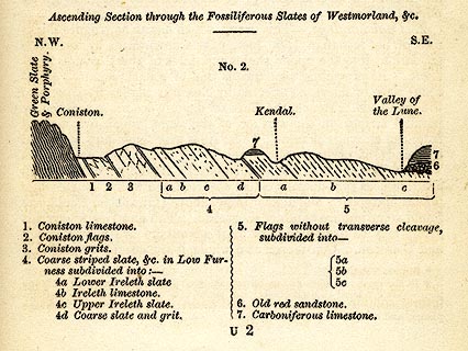 click to enlarge click to enlargeHUD1E4.jpg On p.221 of A Complete Guide to the Lakes, edited John Hudson. printed at caption:- "Ascending Section through the Fossiliferous Slates of Westmorland, &c. / N.W. S.E. / Green Slate &Porphyry. Coniston. Kendal. Valley of the Lune. / ..." item:- JandMN : 327.11 Image © see bottom of page |
|
|
|
||
Lakes Guides menu.