 Old Cumbria Gazetteer
 |
 |
|
| Lorton Vale, Lorton | ||
| Lorton Vale | ||
| Vale of Lorton | ||
| civil parish:- | Lorton (formerly Cumberland) | |
| county:- | Cumbria | |
| locality type:- | valley | |
| coordinates:- | NY14292742 (etc) | |
| 1Km square:- | NY1427 | |
| 10Km square:- | NY12 | |
|
|
||
| evidence:- | descriptive text:- West 1778 (11th edn 1821) |
|
| source data:- | Guide book, A Guide to the Lakes, by Thomas West, published by
William Pennington, Kendal, Cumbria once Westmorland, and in
London, 1778 to 1821. goto source goto sourcePage 144:- "The ride down this vale is pleasant. All the scenes are smiling, rich, and rural. Every dale-lander appears to be a man of taste, and every village, house, and cot, is placed in the choicest site, and decorated in the neatest manner, and style of natural elegance. Not one formal avenue, or straight-lined hedge, or square fish-pond, offends the eye in all this charming vale. The variety of situation gives diversity of views, and a succession of pleasing objects creates the desire of seeing." |
|
|
|
||
| evidence:- | old text:- Clarke 1787 |
|
| source data:- | Guide book, A Survey of the Lakes of Cumberland, Westmorland,
and Lancashire, written and published by James Clarke, Penrith,
Cumberland, and in London etc, 1787; published 1787-93. goto source Page 86:- "... Descending to Lorton, you meet with as rich and beautiful a vale of inclosures, with a serpentine river through them, as any I ever saw," |
|
|
|
||
| evidence:- | old print:- Wilkinson 1810 (plate 39) placename:- Vale of Lorton item:- thatch |
|
| source data:- | Print, uncoloured soft ground etching, Cottages in the Vale of Lorton, Cumberland,
by Joseph Wilkinson, engraved by William Frederick Wells, published by R Ackermann,
Repository of Arts, 101 Strand, London, 1810.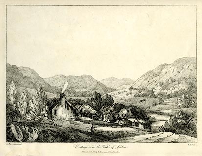 click to enlarge click to enlargeWKN139.jpg Plate 39 in Select Views in Cumberland, Westmoreland, and Lancashire. printed at bottom left, right, centre:- "Revd. Jos: Wilkinson delt. / W. F. Wells sc. / Cottages in the Vale of Lorton. / Published Octr. 1. 1810. by R. Ackermann. 101. Strand. London." item:- Fell and Rock Climbing Club : MN4.39 Image © see bottom of page |
|
|
|
||
| evidence:- | old map:- Garnett 1850s-60s H placename:- Vale of Lorton |
|
| source data:- | Map of the English Lakes, in Cumberland, Westmorland and
Lancashire, scale about 3.5 miles to 1 inch, published by John
Garnett, Windermere, Westmorland, 1850s-60s.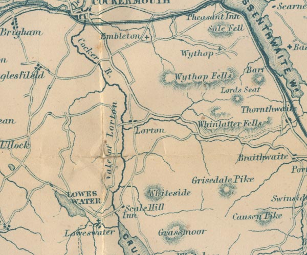 GAR2NY12.jpg "Vale of Lorton" area item:- JandMN : 82.1 Image © see bottom of page |
|
|
|
||
Lakes Guides menu.