 Jansson 1646 NY53


|

|
|
|
gazetteer links places may or may not be labelled on the map |
||

|
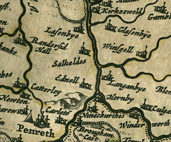
-- battle site, Penrith -- "Penreth" |
|
|
|
-- Briggle Beck |
|
|
|
-- Brougham Castle -- "Brougham Cast." |
|
|
|
-- Carleton -- "Carleto~" |
|
|
|
-- Eamont, River |
|
|
|
-- Eden, River -- "Eden flude" -- "Eden flu."
-- "Eden flud" |
|
|
|
-- Edenhall -- "Ednell" |
|
|
|
-- Glassonby -- "Glasenbÿe" |
|
|
|
-- Great Salkeld -- "Salkeldes" |
|
|
|
-- Hazelrigg Beck |
|
|
|
-- Hornby Hall -- "Hornby" |
|
|
|
-- Langwathby -- "Langanbye" |
|
|
|
-- Lazonby -- "Lasenbye" |
|
|
|
-- Little Salkeld -- "Salkeldes" |
|
|
|
-- Penrith -- "Penreth" |
|
|
|
-- Robberby Water |
|
|
|
-- St Ninian's Church -- "Ninechurches" |
|
|
|
-- Thacka Beck |
|
|
|
-- Winderwath -- "Winderworth" |
|
|
|
-- Winskill -- "Winsgell" |
|
|
civil parishes The area roughly includes parts of parishes:- Culgaith Penrith Great Salkeld Glassonby Lazonby Hesket Hunsonby Ousby Kirkoswald Langwathby Brougham |
||
|
|
||
|
|
Lakes Guides menu. | |