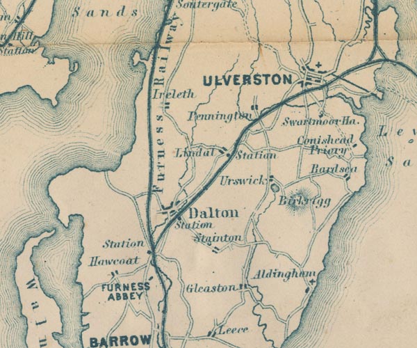
 Garnett 1850s-60s SD27


|

|
|
|
gazetteer links places may or may not be labelled on the map |
||

|
-- Aldingham -- "Aldingham" |
|
|
|
-- Bardsea -- "Bardsea" |
|
|
|
-- Birkrigg -- "Birkrigg" |
|
|
|
-- Conishead Priory -- "Conishead Priory" |
|
|
|
-- Dalton Station -- "Station" |
|
|
|
-- Dalton-in-Furness -- "Dalton" |
|
|
|
-- Duddon Estuary |
|
|
|
-- Dunnerholme |
|
|
|
-- Furness Abbey -- "FURNESS ABBEY" |
|
|
|
-- Furness Railway -- "Furness Railway" --
"Furness Railway" |
|
|
|
-- Gleaston -- "Gleaston" |
|
|
|
-- Great Urswick -- "Urswick" |
|
|
|
-- Hawcoat -- "Hawcoat" |
|
|
|
-- Ireleth -- "Ireleth" |
|
|
|
-- Lindal in Furness -- "Lindal" |
|
|
|
-- Lindal Station -- "Station" |
|
|
|
-- Pennington -- "Pennington" |
|
|
|
-- St Mary and Holy Trinity Church |
|
|
|
-- Swarthmoor Hall -- "Swarthmoor Ha." |
|
|
|
-- Ulverston -- "ULVERSTON" |
|
|
|
-- Ulverstone and Lancaster Railway -- "Midland
Railway" |
|
|
|
-- Urswick Tarn |
|
|
civil parishes The area roughly includes parts of parishes:- Dalton Town with Newton Aldingham Ulverston Osmotherley Egton with Newland Pennington Lindal and Marton Mansriggs Urswick Kirkby Ireleth Askam and Ireleth Barrow-in-Furness |
||
|
|
||
|
|
Lakes Guides menu. | |