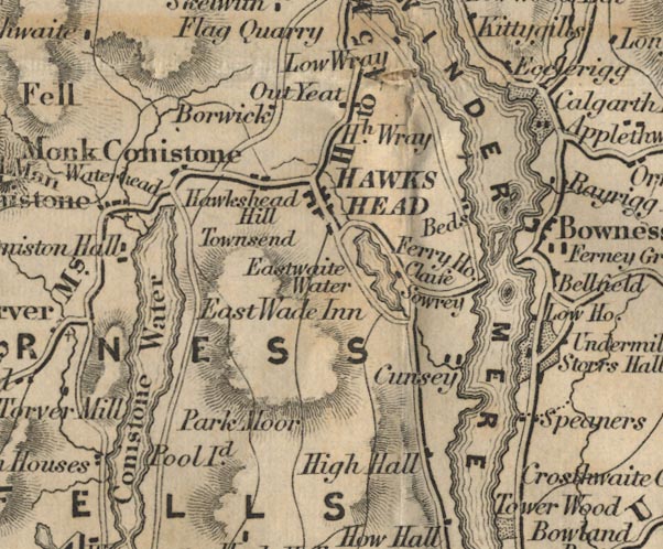
 Ford 1839 map SD39


|

|
|
|
gazetteer links places may or may not be labelled on the map |
||

|
-- Borwick Lodge -- "Borwick" |
|
|
|
-- Bowness-on-Windermere -- "Bowness" |
|
|
|
-- Calgarth Hall -- "Calgarth Hall" |
|
|
|
-- Claife -- "Claife" |
|
|
|
-- Coniston -- "Ch. Conistone" |
|
|
|
-- Cunsey -- "Cunsey" |
|
|
|
-- Easthwaite Inn -- "East Wade Inn" |
|
|
|
-- Ecclerigg Farm -- "Ecclerigg" |
|
|
|
-- Esthwaite Water -- "Eastwaite Water" |
|
|
|
-- Far Sawrey -- "Sowrey" |
|
|
|
-- Ferry House, The -- "Ferry Ho." |
|
|
|
-- Ghyll Head -- "Speaners" |
|
|
|
-- Graythwaite Hall -- "High Hall" |
|
|
|
-- Hawkshead Hall Park -- "Hawkshead Hill" |
|
|
|
-- Hawkshead -- "HAWKSHEAD" |
|
|
|
-- High Wray -- "Hh. Wray" |
|
|
|
-- Low Bank Ground -- "Townsend" |
|
|
|
-- Monk Coniston -- "Monk Conistone" |
|
|
|
-- Near Sawrey -- "Sowrey" |
|
|
|
-- Outgate -- "Out Yeat" |
|
|
|
-- Parkamoor -- "Park Moor" |
|
|
|
-- Peel Island -- "Pool Id." |
|
|
|
-- Ambleside to Hawkshead -- "H to A 5 Ms." |
|
|
|
-- Hawkshead to Broughton -- "B to H 13 Ms." |
|
|
|
-- Sand Beds -- "Beds" |
|
|
|
-- Storrs Hall -- "Storrs Hall" |
|
|
|
-- Water Head -- "Waterhead" |
|
|
|
-- Windermere Lake Cruises -- "WINDER MERE" |
|
|
civil parishes The area roughly includes parts of parishes:- Torver Satterthwaite Claife Lakes Colton Windermere Hawkshead Cartmel Fell Coniston |
||
|
|
||
|
|
Lakes Guides menu. | |