 Ford 1839 map NY13


|

|
|
|
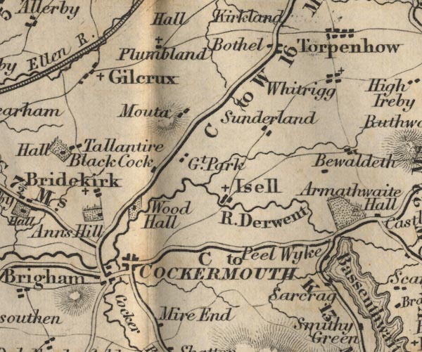
gazetteer links places may or may not be labelled on the map |
||

|
-- Anns Hill -- "Anns Hill" |
|
|
|
-- Bewaldeth -- "Bewaldeth" |
|
|
|
-- Black Cock -- "Black Cock" |
|
|
|
-- Bothel -- "Bothel" |
|
|
|
-- Bridekirk -- "Bridekirk" |
|
|
|
-- Cockermouth -- "COCKERMOUTH" |
|
|
|
-- Derwent, River -- "R. Derwent" |
|
|
|
-- Dubwath -- "Peel Wyke" |
|
|
|
-- Gilcrux -- "Gilcrux" |
|
|
|
-- Isel Park -- "Gt. Park" |
|
|
|
-- Isel -- "Isell" |
|
|
|
-- Moota Farm -- "Mouta" |
|
|
|
-- Peel Wyke -- "Sarcrag" |
|
|
|
-- Plumbland -- "Plumbland" |
|
|
|
-- Cockermouth to Carlisle -- "C to W 16 Ms." --
"W to C 11" |
|
|
|
-- Cockermouth to Maryport -- "M to C 7 1/2 Ms." |
|
|
|
-- Cockermouth to Whitehaven -- "W to C 14 Ms." |
|
|
|
-- Keswick to Cockermouth -- "C to K 12 Ms." -- "C
to K 13 Ms." |
|
|
|
-- Sunderland -- "Sunderland" |
|
|
|
-- Tallentire -- "Tallentire" |
|
|
|
-- Whitrigg -- "Whitrigg" |
|
|
|
-- Wood Hall -- "Wood Hall" |
|
|
civil parishes The area roughly includes parts of parishes:- Blindcrake Bridekirk Setmurthy Plumbland Cockermouth Oughterside and Allerby Bewaldeth and Snittlegarth Wythop Papcastle Embleton Brigham Blennerhasset and Torpenhow Gilcrux Bothel and Threapland |
||
|
|
||
|
|
Lakes Guides menu. | |